
January 22, 2020 | Posted by misfitwanders | Adventures, Hiking, Nature, Sweden, Traveling
Stockholm is the big city capital of Sweden. It’s surprising, but hiking Stockholm is a common activity. There are several different hikes in and around the city. People have been living in the Stockholm area since after the ice age (that’s 8,000 B.C.)! My first visit to Sweden, I had learned that any of the water is drinkable, even in Stockholm. That alone, shocked me! We’re in the biggest city in Sweden, yet all the water is clean. Wow!
I saw many cyclists take to the roads as I took in the wonderful new country. It has been three years now living in Sweden and I’m still in love with the nature here. As you wander in Sweden, you’ll find out that swedes are known for being pretty active. They do several outdoor activities and care for the environment with a passion.

Table of Contents
Being a country that cares about the environment, they have a national urban park called Kungliga Nationalstaden parken. Within this city, they have 3 major nature reserves, Kyrksjölöten, Judarskogen, and Grimstaskogen. Stockholm has two National Parks as well. There’s Ängsö National Park and Tyresta National Park. Even living in a big city, the locals have a chance to escape into nature, which is great! Maybe that’s why they’re laid back instead of stressed out when it comes to work. This makes it easy to start hiking Stockholm since they have nature right at your doorstep.
If you want to learn more about Sweden, then check out Hiking in Sweden.
While you travel through Sweden, it’s best to prepare with the bus and or train. Book now, so traveling can be easier.
Difficulty: Easy-difficult – Distance: 1-50 km- Duration: Approx. .5 hour- 5 days- Coordinates: 59.1690° N, 18,2367° E – Address: Svartbäckens by 361, 136 59, Vendelsö – Transport: Bus, or Rent a car (Map of Trail)

Since it’s only 20 km away from the center of Stockholm, it makes it easy to get to. There are several different trails through Tyresta National Park and many of them loop together. You will be able to switch paths if one of them seems too busy. They have a specific trail that’s for baby strollers and families. There are activities that happen at the park and they even have guided tours.
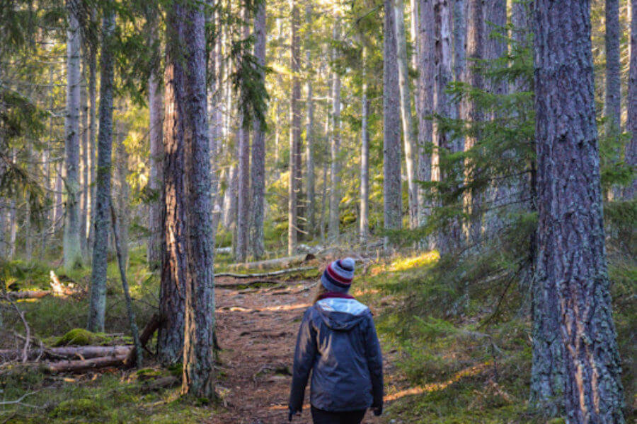
My hubby, our doggie, and I took off to the trails and ended up doing around four of them with switching from trail to trail. It was amazing to have so much nature near the big city so you can start hiking Stockholm county. For me, the stroller pathway was overfilled with families. That’s why we decided to go on other paths and ventured farther into the forests. The trees have markings with the color of the specific path and all of the trails are walked on regularly, so they’re hard to miss. The air felt fresh and welcoming with each step we took. What a beautiful place to wander in!
Take the T-Bana to Gullmarsplan, and switch to bus 807 or 809 to Svartbäcken. Then you have to change at Söderbyleden or Brandbergen centrum (center) and take the 834 to Tyresta by. Another way you can do this is by taking the Pendeltåg 43 to Handen station and then switching to bus 834 at Haninge centrum (center).

Learn more about Tyresta National Park here. This gives you a lot more information on the National Park and its trails. Or download this file so you have a map and information on the park.
Difficulty: Moderate- Distance: 3 km- Duration: Approx. 1 hour- Coordinates: 59.5719° N, 17.5508° E, (Outside of Bålsta) Address: Björkbackavägen 2, 746 51, Bålsta, Sweden- Transport: Rent a car to get to it (Map of Trail)

This trail is not as known, which really makes it all the worth to hike it. At first, I was skeptical. We went through a small industrial area before reaching the path. It’s near a busy road as well. But once we began hiking on this 3 km loop, I was blown away by the greenery. There are boulders sprawled out across the land with moss overtaking them. The path was nicely marked with orange colored paint. Once you reach to the top, there’s a wonderful view and a sign in book.
When we hiked this trail, we noticed the few people that came to it also had their dogs with them, like us. It seems it’s a place that people use for dog walks in this tiny town. It’s sure a nice hidden gem and not far from E18. It’s about 30 minutes away from Stockholm if you’re driving. If you want to step away from the bustling streets, but still hike Stockholm, this is a great path that’s near the city.

Difficulty: Moderate- Distance: 11 km- Duration: Approx. 6 hours – Address: Reavägen, 175 69 Järfälla- Transport: Take a bus, train, or Rent a car (Map of Trail)
The trail starts at Barkarby järnvägstation. A place where one of the paths ends is between Rävsta and Forsbyån. The colored marks for the path are orange. In total, this trail is 450 kilometers long, but you can do the shorter trail at 11 km. If you did the whole trail, it would take you around 22 days.
To get to Barkarby or to the starting point at Dag Hammarskjölds Väg 279, 756 52 Uppsala, you can rent a car or you can take the bus system from Stockholm Central Station. This trail goes the one way and is not a loop.

Difficulty: Easy-Moderate- Distance: 10 km- Duration: Approx. 6 hours- Coordinates: N 59°10.079′ E 018°14.256′, (Outside of Stockholm)- Address: Svartbäckens by 361, 136 59, Vendelsö – Transport: Bus, train, or Rent a car (Map of Trail)
This trail has many paths from it and is over 1,000 kilometers in length, making it the longest trail in Sweden. A part of it goes through Tyresta National Park. It would be the same directions to get to it as if you’re going to Tyresta National Park. It connects with the stroller trail within Tyresta National Park that loops. These paths are marked and at the shop at the entrance, you can buy a map if you need or just take a photo of the map hanging up outside on the information board.
Find out more about this trail at Sörmlandsleden’s website.

Difficulty: Moderate- Distance: 9 km- 25 km- Duration: Approx. 4 hours – 2.5 days – Transport: Bus, train, or Rent a car (Map of Trail)
This one is around 190 km in total and is broken up in sections. If you’re interested in this trail, check out roslagsleden website to learn more about each trail. Several of these trails are in the city. You can begin hiking Stockholm on this path. While you’re on this trail, you’ll get to see old ruins, runestones, and beautiful clear lakes. As you hike this trail, you will get to see farmlands, goats, and cows up close. There are castles that you will get to see along with more nature and the seaside.
Learn more: Roslagen.se
You can buy the book where the photo came from with the map. But they have it only in Swedish.

Don’t forget, prepare for the weather! Dress appropriately and check the weather before going out.

Difficulty: Easy-Moderate- Distance: 12 km- Duration: Approx. 6 hours – Transport: Bus, train, or Rent a car (Map of Trail)
This beautiful lake is a part of the national park. You can walk around it and it will be around 12 km. Any time of the season and this place is a wonderful getaway. On this trail, there are several benches and places to rest. It’s north from Stockholm’s city center. There are three parks that were created in the 1780s that surround this lake. In this area, there’s also a botanical garden and the Swedish Museum of Natural History. This place is popular for swimming, picnics, and as a nice hangout from the busy city life.

Difficulty: Easy-Difficult – Distance: 2 km- 5 km- Duration: Approx. 30 min.- 4 hours – Coordinates: 59.2849° N, 18.1469° E – Address: 128 48 Nacka Transport: Bus, train, or Rent a car (Map of Trail)
Here, you get to see lakes, wetlands, and pine trees. There are parts of some of the trails, where you walk past camping areas and a golf course. This area offers a few different trails. The hikes vary with difficulty and length. Check them out when you get there and enjoy hiking Stockholm’s Nature Reserve. Other activities are also happening in this nature reserve. Plus, they have restaurants and places to stay. It’s great to start your journey in Hellasgården.
Download for two trails: https://www.guidetosilence.org/pdfs/NackaresENG1.pd

If you want to learn more about how it is to hike in Sweden, check out this article that breaks it down for you!
Any links on here, I recommend it from my experience and believe it’s something to look into. I make a commission but it doesn’t affect the price. So it turns into a win win!


