
June 29, 2020 | Posted by misfitwanders | Adventure, Adventures, Hiking, Lifestyles, Nature, Sweden, Traveling, Trekking
Herds of reindeer pranced out of the forests and across the paved road, as if there was nothing speeding towards them. We slowed down and stared at the reindeer that were losing their winter pelts. They weren’t bothered by us and gobbled up the newly green grass. This happened to us several times as we drove to the Kebnekaise hike.
Trees were scattered in groups and the farther up we traveled, the smaller they seem to become. It’s maybe because wintertime in northern Sweden has barely any sunlight for about a month or so. Small towns are spread out with the wilderness in between. We drove from Karlstad, Sweden to Nikkaluokta and it took around 18 hours. If you do decide to drive, look out for reindeer! They don’t care at all about vehicles, so you have to pay attention.
Hiking Sweden

This article you tell you the ins and out about Kebnekaise, Fjällstation, and the activities that are offered in the area. You’ll get to learn about places to stay, what to bring with you, and how long the journey is. This trip is one that’s best to stay prepared for since it can take days. It just depends on the way you decide to get to the Fjällstation from Nikkaluokta. I explain the options you have in this as well! Enjoy traveling to northern Sweden!
Table of Contents
We made it to Nikkaluokta, Kiruna, the beginning of our journey to start the Kebnekaise hike. As we rolled in, we saw several campers sprawled out around one of the parking lots. We came when everything was still closed. But if you plan to come when things are open, they have a lot to offer. Even if it’s closed, they have a bathroom that you can use, as long as you have 10 kronor (it’s a Swedish coin, Swedish money). This is near the main triangle red building.
If you want to learn more about the money in Sweden, check out Hiking Sweden. In that article, I explain more about it along with the dos and don’ts when it comes to hiking in Sweden. Check it out here!

If you’re planning on going to the Kebnekaise hike or wandering to the Fjällstation (the mountain station) you might want to rest up first. They have a variety of accommodations from camping, to a 6 bed apartment. Just make sure to book it in advanced since it can get pretty busy. Check out Nikkaluokta.com and make a booking for a place to stay.

The restaurant Skáidi is where you can have breakfast, lunch, and dinner while you enjoy a beautiful view. This restaurant uses local ingredients in their traditional cuisines. If you’re traveling with a big group, it may help to book here. There’s a café if you just want to relax after your journey or before you even start. Take a warm sip of some coffee and take in the wonderful views. Learn more about the food and drinks offered here.
They offer a lot of activities that you can do. You can take on the Kebnekaise hike, go canoeing, enjoy fishing, day tours around Nikkaluokta, Kungsleden, or a river safari. Check out their activities here for more information.

E-mail : info@nikkaluokta.com
Number : (+46)980-550 15 (calling with international phone)
0980-550 15 (calling with Swedish phone)
There are different kinds of tours you can go on in this area. There are boat tours, canoeing, hiking, quad riding, snowmobiling, and safari tours. You can check out a nice hike, where you get to see the Kebnekaise mountain. This trail doesn’t go up it, but near it, so you get great views of the mountain. There are tours in the Fjällstation that are offered as well! Scroll down to read more about the Fjällstation.
Visit Kebnekaise MountainMy backpack was cinched up to my back and I was ready for us to begin our journey to the Kebnekaise hike. I didn’t think about a method of transportation to reach it. I had my feet, plus, when we started our trip to Kebnekaise, all the restaurants, transportation, and other activities were closed. We were on our own, which is nice, no crowds. But now, if we do decide to venture to the Kebnekaise hike again, I want to try out the helicopter.
This was something that wasn’t even on our radar. We thought, “Oh yeah, no problem hiking it all!” Boy were we tired by the end of the Kebnekaise hike. I thought about how much I wanted to ride in a helicopter, seeing the views from high above and not worrying about each step I would have to take. The helicopter is open now, so if you want to just skip the hike from Nikkaluokta to the Fjällstation this would be it! Check out Kallaxflyg.com to learn more. You should be able to book it on there as well.
Or give them a call: +46 980-81 00
In the summertime, they have boats running. It wasn’t open when my hubby and I hiked, but I know that they are open now. This would have you only walk ¼ of the trail to the Fjällstation. The place where you can get on the boat is near Enoks Restaurant and the water makes this area filled with tranquility and peace. This is a nice place to walk to just to see the mountains from afar and see the glacier water. The boat doesn’t bring you directly to the Fjällstation but it cuts your time a lot with walking to it since taking the boat goes over 10km. Check out the times for the boat here. Enoks.se will tell you the prices and the timetable for it.

If you’re planning on traveling with more than 10 people, then you’ll have to book it. You can email or you can call them.
info@enoks.se
Andreas Sarri +46 (0)73-031 70 27
If you’re thinking about a River Safari, you can find more info. at this website. Check it out here.
First step to get to Kebnekaise, is that we need to hike to Fjällstation. This trail was at first, a nice flat road. But as the trail goes on, there are obstacles in the way. If you hike to the Fjällstation from Nikkaluokta, it’s 18.6km one way. It took us around 6 hours with stops for resting and taking photos, breakfast and lunch break. Once we hiked to Enoks Restaurant, I was blown away by the reflection in the translucent water. You could see the mountains perfectly reflected in the glacier waters. This is the place where the boat is as well.

After we finished our breakfast, we began our journey towards the Kebnekaise hike once again. The trail started becoming a little harder in areas. It would jut upwards and downwards with loose stones taking over the path. We even had to hike through 1 meter (3 feet) of snow in the middle of June. But it really depends when you plan on taking on the Kebnekaise hike. You may have a lot of snow or a lot of water. Be prepared with your gear! Learn more at Swedish Tourists Association’s website where they will tell you more about the Kebnekaise mountain station, Fjällstation.

Setting up a tent is free! You just need to be at least 150 meters from the station due to a fire hazard. It’s 350 kronor for a day fee if you want to be able to use the service building, which has a kitchen, toilets, showers, sauna, and a nice drying room. The views of the mountains surrounding the valley are spectacular!
There are a few options to choose from when it comes to accommodation. They have a hotel, hostel, cabin, or a guesthouse. The prices vary along with what is offered. You can learn more at the STF website.
Take in the wonderful views as you dine on traditional dishes at Elsa’s Restaurant. They have course meals that you can book. Or if you want a guide on the Kebnekaise hike, they can make that happen. They even have tours on the King’s trail/ Abisko. Check it out here!
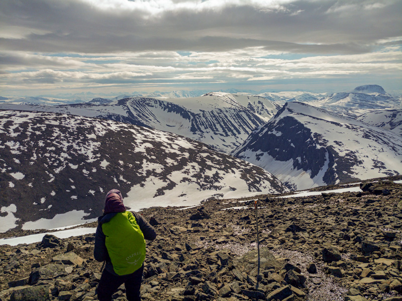
As we made it to the Fjällstation, we could see the tall mountains in the distance. It hovered above us as we began our hike to it. Loose rocks became a common thing on the path as we took on the Kebnekaise hike. Each step brought us closer to the top. The top of it was so foggy, you could barely see in front of your hand. But at the “Old top Stuga”, the view was breathtaking! Mountains could be seen and, in the distance, the valley that we hiked from.

This Kebnekaise hike involves glacier hiking, so you’re going to need the right gear for that. You can rent the gear or it might be included in your tour. It’s highly recommended to do this trail with a certified tour guide. The Western and Eastern trail start at the same place then they split and there’s a sign, so you know. This is a steep hike near Kebnetjåkka glacier and then it flattens. Once this happens, you must cross Björlings glacier. Go with your gut feeling and watch where you put your feet. There can be snow covered crevices in the glacier. There’s Gudhjohnsens hylla, a shelf that is awaiting you at the end of the glacier. Watch out for loose rocks as you’re on this trail.

This trail is the longer one, but it’s a little easier than the Eastern Trail. Plus, you can do this one without a guide. There are red painted stones on this trail, but they’re only in the trail partially and not always so visible. It really depends when you decide to go up Kebnekaise hike since they could be covered in snow.

As we ventured up one of the Kebnekaise hikes, it became strenuous with the stones that felt as though they would slip from under your feet. I looked at the trail in front of us, and my gut dropped. The trail went straight up the side of the mountain, in SNOW! My nerves felt like they were on end. But I pushed forward and once my hubby and I made it to where the trail began zigzagging, rain pelted down on us. The higher up we got, the more the rain turned into icicles. Both of us were just about to give up and turn back. Just then, the blue sky started to peak out and the crazy weather cleared.

The weather can become even more unpredictable the higher up the mountain you get. That’s why they built these cottages called, “Stuga” in Swedish. So if you see a sign that says that, that’s what it means. There is one at the old top and there is one at the new top of the mountain. They give you shelter if the weather is not on your side.These little structures are just a room with benches and flat areas off the floor. It offers shelter if necessary.

Before you even begin your journey onto the Kebnekaise hike, stop at the office and make sure you have the local emergency phone number. Below is the Mountain Safety Council. They have an email and a phone number. Here are several different contacts depending on where you’re at in Sweden. Check it out here.
fjallsaker@naturvardsverket.se
+46 (0)10-6981053
Kebnekaise hike started out relatively warm. But as we progressed to the top, a chill ran through my body. Having the extra layers and waterproof pants saved me! I highly recommend wearing a waterproof jacket, waterproof pants, and a must, waterproof boots. I would have been soaked the whole hike if I didn’t have these.
Plus, bringing two or three pairs of socks and gloves are worth it. Another must as you hike this trail is a hat to keep your head warm when you get closer to the top. Don’t forget to bring a water bottle that holds at least, 1.5 liters of water. It would be best to bring a thermos or a small propane with a burner. We had this with our two metal cups! It was great getting to the old top and being able to have tea in the little cabin there.
My Meindl waterproof boots were bought just for this trail! I broke them in before wearing them for the Kebnekaise hike. They were the best investment for this hike. Since they go over my ankles, I didn’t have to worry about rolling my ankle and they are warm! Check them out here!
Check out my article, Hiking Gadgets to see some of the gear I have used on hikes.

Check out some of the best gear I have used when I go hiking in this article.
The best food to bring would be dry and dehydrated food. My hubby and I had two bags of premade pasta. All we had to do was add hot water to each bag and let it sit. A banana or an apple is a great thing to have in your pack as long as it can be in a safe place and not get squished. Otherwise, you can bring a bag of dried fruit and nuts. That’s always good to have since it helps you gain energy and get some of the vitamins and nutrition that has depleted from your body.
The best time to go really depends on the weather and what kind of season you’re thinking that you want to take on the Kebnekaise hike. People have ventured up there in all the seasons. My hubby and I hiked up it in the middle of June this year. It felt like a good time for us since there wasn’t so many people. But that’s probably because they just recently said that you can travel within Sweden again.

As we hiked up Kebnekaise, there was a couple of shallow streams we had to get over. Parts of the hike still had snow, but it was quickly melting away. On our way down, we did some sledding to ease the pain in our knees. If you plan on doing this, make sure to do it where you see other tracks. It wouldn’t be good to fall through the snow and into the streaming water below.
Always check the weather. In this area, it drastically changes, so try to stay prepared. The two of us hiked to the Fjällstation and camped there for the night. The next day, we checked the weather and then decided to start our journey up the Kebnekaise hike. If it had been bad, we would have waited it out in the valley. So, we took off a few days extra just in case we ran into bad weather.
You can drive to Nikkaluokta, like we did, or you can take the public transportation. From Stockholm central, driving would take about 15 hours and the public system would take a whole day to get there. Renting a vehicle or going with some friends in Sweden is probably better if you’re on a time crunch.
Click here to see google directions for driving

Click here to see google directions for public transportation.
If this is your first time visiting the wonderful Sweden, then you can learn more information from Hiking in Sweden article.


If you want to find other information on hikes, check out Top 100 Hiking Blogs.
Mostly all of the links are affiliate links, which means I can make a commission. But don’t worry, it doesn’t affect your price. Your price will be the same.


