
It took us around 3 hours to drive to Tiveden National Park from our home in Värmland. We began our journey before the sun came up, so my hubby was on driving duty. I needed my sleep and once I sat in the passenger’s seat, I was out. Two hours passed and as the light came up, I was ready to go. My hubby was beginning to look all drowsy eyed, so it was time to take over. My eyes widened even more the closer we go to our destination. Forests engulfed us and it felt like we’ve been brought to the past before man made cities. What a sight! The coordinates to the National Park is 58°43′00″N 14°36′20″E.
If you’re interested in Hiking in Sweden, there’s a few things that will be good to know.
Check out Hiking in Sweden
Table of Contents
It’s hard to get there without a car. So, it would be best to rent a car to get to and from Tiveden National Park. You can take highway 49 for an easy route and look for signs for Askersund. They will have parking at the main entrance and the north-western part of the park. At the main entrance, there are bathrooms and an exhibit that’s very informative about all the trails and the park.
They have a great website that’s dedicated to this park, where you can learn more about places to stay. They even have restaurants and places where you can get food.
There are around 6 different options of places that you can camp or bring a motorhome to that are near the park. Check out my recommendations for good outdoor gear that I know work, at least they’ve worked for me!
There are a few different hostels that you can choose from if you want the cheaper route. One of them is very ecological and will let you borrow bike that they have to ride to the park that’s about 500 meters away.
There’s a cabin up for rent that’s cozy for two people. This place lies within nature, so it can be peaceful. It has a bathroom and wifi is available.
https://www.booking.com/hotel/se/hamgarden-nature-resort-tiveden.html
Check out Tiveden’s webpage to learn about all the different places that you can stay or the places that offer food that’s near or inside the National Park.
Since this place is a national park, you’re only allowed to make fires in the specific places that they have created firepits for the visitors to use. These places are going to be near the entrances, and wood will be stacked near. If you ran into the issue of them having no wood, then you’re just out of luck. But that shouldn’t be a problem. You can’t take any wood from the natural environment. In the areas with the firepits, they will have picnic areas and recycling stations.
There is Kärringgudden and Mellannäsudden that you’re allowed to camp at. But it’s for one night only and you’re on a time limit. It’s 18:00 at night to 10:00 in the morning. The rest of the time, no one is allowed to camp in Tiveden National Park.

Enjoy the outdoors on some of the hiking trails or do some cycling. You can even go horseback riding here. The lakes that are in Tiveden National Park, you can go paddling in them if that’s something that you’re interested in. They offer tours for many of the activities. Check out Tiveden.se to learn about all the activities.
You Can Check out the Audio Guides Here:
There’s over 34 kilometers of marked trails. Enjoy several different kinds of hikes as you explore the nature. Some trails go through the deep rift valleys and will take you on top of the rocky hills. Many of these trails are hilly, so be prepared for the journey. Make sure that you’re aware of the difficulty of the paths before heading on them. Each trail is a loop, so many of the hikes connect.

There are several different trails that you can take. At the main entrance, they explain which colors represent each trail. At the main entrance, you’ll be able to see a map of all the trails and begin planning your hike. Take a photo of the map with your phone so you have it as you hike. That’s what we did as we hiked several trails.
It depends when you start, but it’s possible to be able to do a few trails in one day. All the paths are nicely marked with their specific colors. As long as you remember the color of the path you’re walking, you shouldn’t have any problems. I know that I would have gone down the wrong path if I didn’t have my handy dandy man with me.
My hubby, dog, and I enjoyed our adventures on these trails. The sun shone down on our path as we hiked through the national park. It felt nice being surrounded by nature once again. A breeze picked up and filled me with the fresh air. I began to feel alive. An energy filled me as we started our hike. Excitement seeped from me as I took in nature’s beauty. It’s rejuvenating to be out in the outdoors!

Difficulty: Moderate- Difficult – Distance: 4.6 km- Duration: Approx. 3.5 hours
Trollkyrkerundan means the troll’s church loop and this starts at the main entrance. This path is marked with red and a white dot representing the first trail. Don’t forget to decide how you want to take your trail. There’s a shorter route and a longer one that you can see on the map at the main entrance. On this hike, there are steps and railings as you go the Stora (big) and Lilla (little) Trollkyrka.

Difficulty: Moderate – Distance: 2.2 km- Duration: Approx. 2 hours
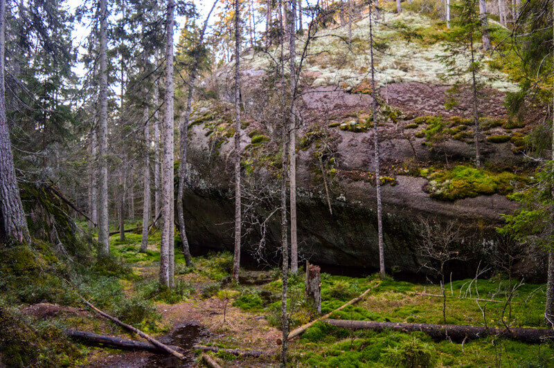
Stenkällerundan means the stone well loop. Even with it being a short trail, halfway of it becomes difficult. You can start this trail at the main entrance and that’s also where it ends. It’s considered the most popular trail in Tiveden National Park. This was actually the first path we did, and I was blown away when I saw the huge boulders! There are steps to help you go up some of the hills with beautiful views.
The light hit lake Vättern just right as I looked over the land. Trees surrounded the area, but you could get glimpses of the view. The markings to follow for this path are yellow with two dots.

Difficulty: Moderate- Distance: 1.3 km – Duration: Approx. 1 hour
Tärnekullerundan means thorn hill loop . Being short helps the difficult part become endurable. This loop starts at Vitsand and that’s where it ends as well. Here in Sweden, you can swim in any lake. Check out lake Trehörningen on this trail. This path goes through forests to caves. Much of the trails, you’ll get to wander in areas with boulders. A light orange with three dots will be the marking for this hike.
The views on this trail were amazing! I followed the stream through the trees as my dog waited for me. The beauty of this place felt untouched. The way nature should be. Although there’s man made bridges and stairs, they tried their best not to destroy the National Park in anyway.

Difficulty: Moderate- Difficult- Distance: 9.5 km- Duration: Approx. 6 hours
The name, Trehörningsrundan means the three horns loop. This trail is the longest one in Tiveden National Park. You get to wander all the way around lake Stora (big) Trehörningen. With this path, you’ll get to enjoy all the different kinds of vegetation and nature that the park has to offer. The marking color for this hike is purple with four dots.
Difficulty: Difficult- Distance: 6.7 km- Duration: Approx. 4.5 hours
The name, oxögabergsrundan on this trail means the ox eye mountain loop. This trail goes through the old part of the forests. As you follow the curvy path, there are parts where you go through the valley rifts and mossy grounds. This has demanding times at the beginning of the trail. The marking for this hike is a light blue with five dots.
Difficulty: Easy- Distance: 1.9 km- Duration: Approx. 30 minutes
Mellannäsrundan means the middle peninsula loop. If you want the easiest trail in the park, then this is it! On this path, you’ll hike between the lakes, Stora (big) Trehörningen and Lilla (little) Trehörningen. On this trail, you get to see eskers. One of them, you can clearly see charcoal remains. The path has green with six dots for its markings.
Difficulty: Moderate- Distance: 2.8 km- Duration: Approx. 1.5 hours
This trail has a story behind it. Junker Jägarerundan means the squire hunter loop. This is a trail definitely worth hiking. On this trail, you get to see a gigantic boulder that the story is about. This gigantic rock wasn’t here at first. Over 10,000 years passed and it was brought to this spot from ice. As the story goes, Junker Jägare loses the woman he loves. There’s a sign posted up near the rock that explains a little more. The trail is marked with the color white with 7 dots.
When I saw this 15 meter tall rock, I was speechless. It looked as if it looked down on everything surrounding it. The spot felt like a peaceful area, where you can just look up at the huge boulder in awe and wonder.

Difficulty: Easy – Distance: 1 km – Duration: Approx. 30 min.
Vitsandsrundan means the white sands loop. You can check out the nice white sandy beach as you hike this trail. As you hike this easy short trail, you’ll notice that it hasn’t been fully marked yet. Follow the orange marked trail (Tärnekulle) until the Vitsands caves. There you’ll follow an unmarked path to the east. After you pass the road, there will be the white trail (Junkerjägarerundan). You head to the south to enter Vitsand. The markings for this trail will be black with 8 white dots (when they mark it).
Difficulty: Moderate- Distance: 4.2 km- Duration: Approx. 3 hours
Stigmansrundan means the thief’s loop. This trail starts and ends at the main entrance. It can take some time, since the pathway goes through a narrow rift valley. As you begin to head back, you will pass Stenkälla or near Trehörningens beach. There are beautiful views as you take on this hike. They have marked this trail with grey and nine dots on cloth pieces around trees.

I’ve found that with hiking, it helps to have a good water bottle with you! I’ve gone through several, but that’s not because the water bottles were bad. I’m just forgetful and put it in my backpack where it’s likely to fall out!
Any links on here, I recommend it from my experience and believe it’s something to look into. I make a commission but it doesn’t affect the price. So it turns into a win win!


